Announcement

Collapse
No announcement yet.

Who likes looking at maps?

Collapse
X
 
  • Filter
  • Time
  • Show
Clear All
new posts

    Who likes looking at maps?

    Furtho wrote: Country by country, "Europe's second most useful foreign languages". Click here for a bigger version.

    Not quite sure I get this. Is English considered to be the first most useful in every single country? I find that hard to believe in a country such as Portugal where surely Spanish is more useful than English. There must be plenty of countries who would consider English as second most after the language of an immediate neighbour.
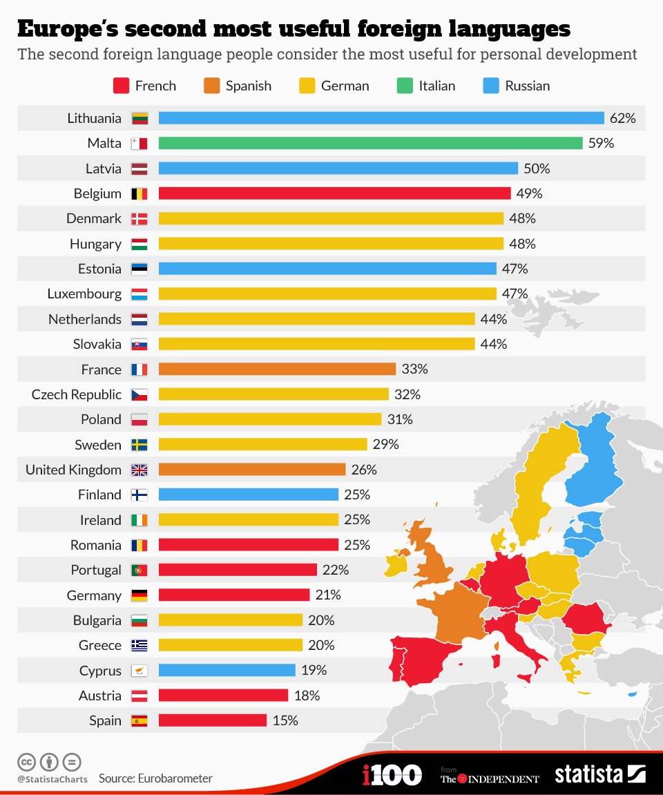
    Also how is French a foreign language in Belgium when 40% of the country consider it their first language?

    Comment


      Who likes looking at maps?

      Gawpus wrote: Have we had this yet?

      Live global wind patterns:

      windyty.com
      Wonderful. Could lose myself for hours just looking at the Southern Hemisphere from directly over the South Pole.

      Comment


        Who likes looking at maps?


        Every single men's water polo Gold Medalist this century was born within the circle.

        Comment


          Who likes looking at maps?

          Sean of the Shed wrote:
          Not quite sure I get this. Is English considered to be the first most useful in every single country? I find that hard to believe in a country such as Portugal where surely Spanish is more useful than English. There must be plenty of countries who would consider English as second most after the language of an immediate neighbour.
          I think it does what it says on the tin. The most useful foreign language will one assumes typically be English, but in Portugal I agree it must be Spanish, with French perhaps surprisingly keeping English out of the top two.

          Comment


            Who likes looking at maps?

            Part map, part illustration, wholly gorgeous. Alfred Mahlau's poster promoting tourism in Lübeck, 1934. Click on the image for a larger version.

            Comment


              Who likes looking at maps?

              That is quite beautiful.

              Wow, Mahlau is brilliant.

              Comment


                Who likes looking at maps?

                Similar to the Windyty map, here's a map showing migration routes in the Americas that animals will take to escape/adapt to climate change

                Comment


                  Who likes looking at maps?

                  Furtho wrote: I didn't know Fantasy Olympic bid maps were a thing. That's great.
                  Found it:

                  Comment


                    Who likes looking at maps?

                    Oh my eyes. I'd need to be able to print that out on an A0 piece of paper to be able to read the detail. But still, I'm glad someone is doing that sort of stuff.

                    It's been a while since we've had a map from a railway station wall and while this isn't a route map like most previous efforts, it just about fits the bill. This is a Soviet-era mosaic on the wall of Electrosila railway station, St Petersburg. The accompanying text is one of those famous Lenin quotes: "Communism is Soviet power plus electrification of the whole country." Click the image for a larger view.

                    Comment


                      Who likes looking at maps?

                      I've tried taking pictures of the two maps at Victoria that I walk past every day but they are behind plastic and the lighting just gives me glare.

                      Comment


                        Who likes looking at maps?

                        Levin, if you're interested in previous examples on this thread, go here.

                        Comment


                          Who likes looking at maps?

                          tee rex wrote: The San Francisco Olympics that won't be happening ...


                          Fantasy Olympic bid maps are often a treat. I've been looking for Birmingham's, but it was pre-internet, so no joy.
                          I've noticed that Levi's stadium is hosting *football* and rugby. Heh.

                          Also, very interesting that the plan was for SF to build an Olympic Stadium to host - ???? - after the 49ers planned their move to Levi's. Would Candlestick II's legacy have been as an MLS stadium? As a carrot to entice the 49ers back to San Francisco? A distinct possibility given Levi's seems to be a lemon.

                          I'm a little unsure why you'd host basketball, a blue riband event at a US games, at a 10,000 seat college arena but the volleyball at an 18,000 seat NBA-sized arena.

                          Yeah, the Games are a total boondoggle, but I can't lie, seeing a thought-out plan for where events would be in the Bay Area makes the idea enticing. Also, the infrastructure improvements would have been worth seeing, which leads me onto:

                          Design Your Own SF Subway Map!

                          The SF MTA is putting out to consultation plans for expanding the SF subway system and you can draw your own map and send it to them.

                          Here's mine:


                          Subway down Geary, extending the Chinatown line extension to the Marina and the Presidio, A subway from the Castro to UCSF and the ballpark, a subway from Bernal Heights to the Civic Center, and more. All yours for the low price of a few hundred billion.

                          This is officially what SF is focusing on, which makes me think I might have had a future as a transit planner.

                          Comment


                            Who likes looking at maps?

                            Scottish Index of Multiple Deprivation Data maps. Difference between the big two cities is striking.

                            http://simd.scot/2016/

                            Comment


                              Who likes looking at maps?

                              [quote]Flynnie wrote:
                              Originally posted by tee rex
                              The San Francisco Olympics that won't be happening ...

                              Here's mine:


                              Subway down Geary, extending the Chinatown line extension to the Marina and the Presidio, A subway from the Castro to UCSF and the ballpark, a subway from Bernal Heights to the Civic Center, and more. All yours for the low price of a few hundred billion.
                              I did that too. Subway down Geary, then turning south on Sunset (I think) and gradually hooking back to Daly City, the Central line going to the Marina in one direction, then becoming the second Transbay tube with stops on Alameda island, Jack London Square, and under the coast highway to meet up at El Cerrito.

                              Comment


                                Who likes looking at maps?

                                Here's a 1902 photograph of a classroom on St Kilda - the westernmost islands in the Outer Hebrides, from which the entire population was evacuated in 1930 - relevant to this thread on account of the presence on the wall of a big map of England and Wales. Click here to see a larger version.

                                Comment


                                  Who likes looking at maps?

                                  Furtho wrote: Here's a 1902 photograph of a classroom on St Kilda - the westernmost islands in the Outer Hebrides, from which the entire population was evacuated in 1930 - relevant to this thread on account of the presence on the wall of a big map of England and Wales. Click here to see a larger version.

                                  That it's a map of England and Wales is bizarre!

                                  Comment


                                    Who likes looking at maps?

                                    Map of new towns. Click here for larger version.

                                    Comment


                                      Who likes looking at maps?

                                      When I was at school in Glasgow, those 6 towns in Scotland were the subject of both geography, and social studies.

                                      Furtho, may I just take this moment to thank you for all your (and others) fantastic work on this thread.

                                      Comment


                                        Who likes looking at maps?

                                        Cheers Gero.

                                        This is Daedongyeojido ("The Great Map of the East Land"), a beautiful and very detailed map of Korea made by Kim Jeong Ho in 1861. It's the subject of a film called The Map Against The World, released in Korea and the US this month. Click on the image for a larger version.

                                        Comment


                                          Who likes looking at maps?

                                          This might well have been shared on here before, but...

                                          A different kind of maps.

                                          And a different take on the same idea, only with 'draggable' maps.

                                          Comment


                                            Who likes looking at maps?

                                            Those are great, Clive.

                                            Comment


                                              Who likes looking at maps?

                                              Beautiful interactive map showing "the location of every single cargo ship over the course of 2012", here.

                                              Comment


                                                Who likes looking at maps?

                                                Furtho wrote: Beautiful interactive map showing "the location of every single cargo ship over the course of 2012", here.
                                                That's lovely!...Particularly fascinating to watch the few ships around places like Greenland and Iceland and watch what they were up to.

                                                Comment


                                                  Who likes looking at maps?

                                                  Here's a 1902 photograph of a classroom on St Kilda - the westernmost islands in the Outer Hebrides, from which the entire population was evacuated in 1930 -
                                                  There's something painfully sad, difficult to articulate, about the St Kilda story. Even though the evacuation was an unavoidably necessary and positive change in the lives of the islanders, the sense of loss and traumatic separation must have been immense.

                                                  Edit: of course, nothing compared to the loss of place combined with bereavement suffered by millions of refugees right now. I suppose I was particularly moved by the St Kilda thing because I first learnt of it in an obituary of Norman John Gillies (died 2013), who was also, as it happens, bereaved as a small child (due I think in part to the remoteness of the island from proper medical facilities which might have saved his mother).

                                                  Comment


                                                    Who likes looking at maps?

                                                    For both map and tube/train nerds (which seems to be a few people on here) http://www.citymetric.com/transport/map-londons-tube-shows-disused-stations-track-layout-and-more-2429

                                                    Comment

                                                    Working...
                                                    X