
Cheers Aitch, that really is worth zooming in on, if only to spot the rude placenames...
-
-
Map showing maximum speeds allowed on highways by country. The colours denote the colour used on road signs to indicate a motorway.

Comment
-
Rather elegant map on the cover of the promotional booklet Tees-side Enterprise, 1949. More information here.

Comment
-
Bulgaria looks high until you actually drive through it (and I have, a few times) and realise that there are no motorwaysOriginally posted by Furtho View PostComment
-
As an avid player of European Truck Simulator, I think I knew most of those already (though truck speed limits are lower most places).Comment
-
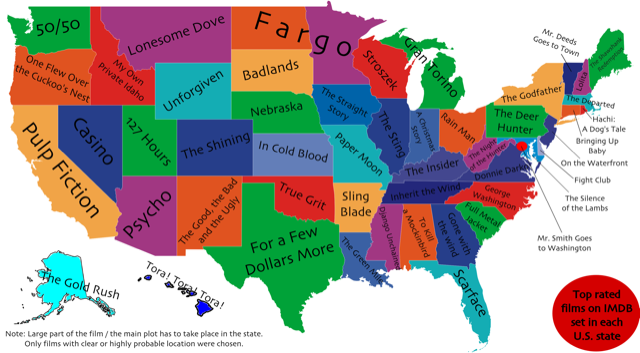
Most popular films in the US, state by state
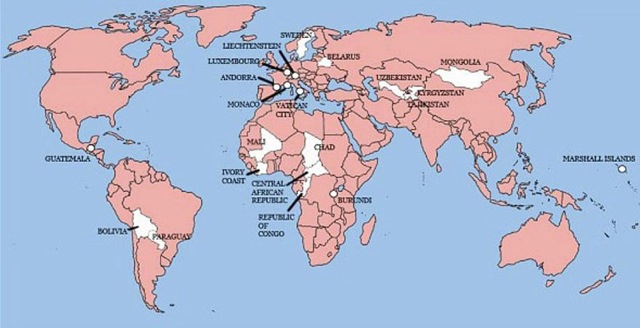
Countries not invaded by the Brits (only 22 of them):
 Last edited by Aitch; 12-09-2017, 09:12.
Comment
-
It's not most popular films by state, it's most popular films primarily set in each stateComment
-
By way of apology, the popcorn and root beer are on me. Sorry for the misleading information.Originally posted by ad hoc View PostComment
-
Actually I'm wrong, it's not even that, it's most highly rated (not most popular) films set in each state. I've never even heard of Stroszek, or Hachi.Comment
-
Ok, popcorn, root beer and choc ices in the intermission.Originally posted by ad hoc View PostComment
-
IMDB readers really seem to like (spaghetti) Westerns.Comment
-
Some cartographers may take the view that this is not strictly speaking a map. But hey. I like the way Bavaria curves around the top.

Comment
-
As someone who's grown up in an era where Baden and Wurtemberg are the same place, the disparity between the two is very notable.Comment
-
Then again, Czechoslovakia was a thing when you were aware, and current per capita beer consumption in the Czech Republic is twice that of SlovakiaComment
-
That's a fair point, and a quick look at how Baden-Wurttemburg splits explains the beer-differential. Baden is basically Alsace, mirrored eastwards across the Rhine. And I already know that that area is wine country. It's less clear, actually, why Slovakia drinks less beer than Bohemia and Moravia.Comment
-
It's a cultural predilection for spirits over beer and wine in Slovakia.
The two countries are very close when you look at alcohol consumption, rather than beer consumption.Comment
-
Also notable - but, I think, probably explained by the way I frame this - is how much less beer Protestant northern Germany drank than (the non-winemaking parts of) Catholic southern Germany and Austria.Comment
-
If you've drunk beer from Northern Germany that isn't a surprise.Comment
-
-
That's excellent.Comment
-
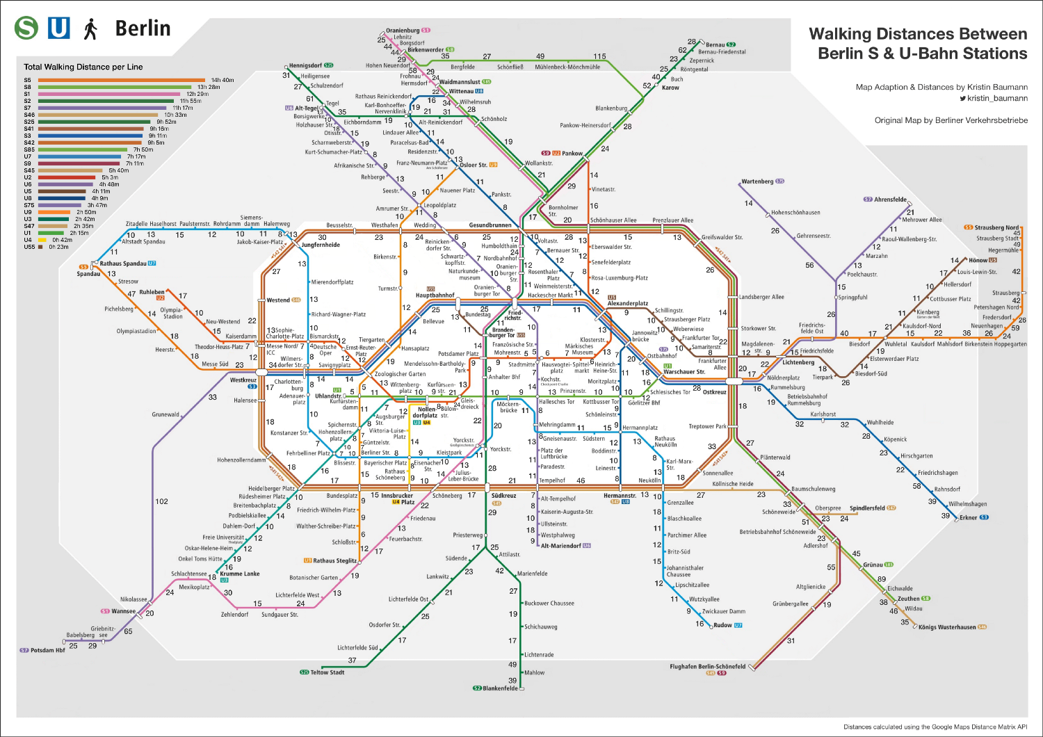
Ausgezeichnet!
And genuinely useful for anyone who finds themselves in Berlin.Comment
-
A supplement added to Bartholomew's road atlas of Great Britain depicting the route of the then-new M1 motorway, which was opened on 2nd November 1959. More info is here and a super-large version for zooming in on (and, for me, looking at the landscape of north Bucks in the years before the new town of Milton Keynes started to be developed) is here.
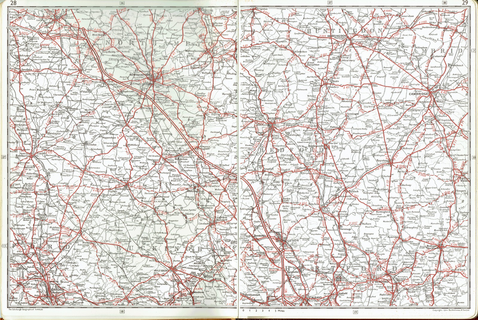 Last edited by Furtho; 21-09-2017, 12:50.
Comment
-
It's also damn fine for studying all the railway lines that were Beechinged...Comment
-
Map of extreme climate event attribution studies. So far I'm finding actually attempting to use it rather fiddly, but it's a good idea so I'm posting it (and the fiddliness is probably down to me anyway).Comment

Comment