Lane is an Eastern Pacific storm, not an Atlantic one, so you may not have known about it.
The naming convention changed in 1978, where it went to Boy-Girl. And, in fact, in 1978 there was a Tropical Storm Lane which plodded along a few hundred miles south of Hawaii.
Just looking it up, and it turns out that nearly 100 Atlantic hurricane names have been retired, but only 15 Eastern Pacific ones have been retired in the last half century. Presumably that's because most hurricanes in the eastern pacific basically meander around a thousand miles off the coast of Baja before getting pushed westwards, or a few hundred miles south of Hawaii, and don't interact with humans at all apart from making some exciting surf for California beaches. You just don't hear much about the Pacific hurricanes because they just aren't a big deal for most people.
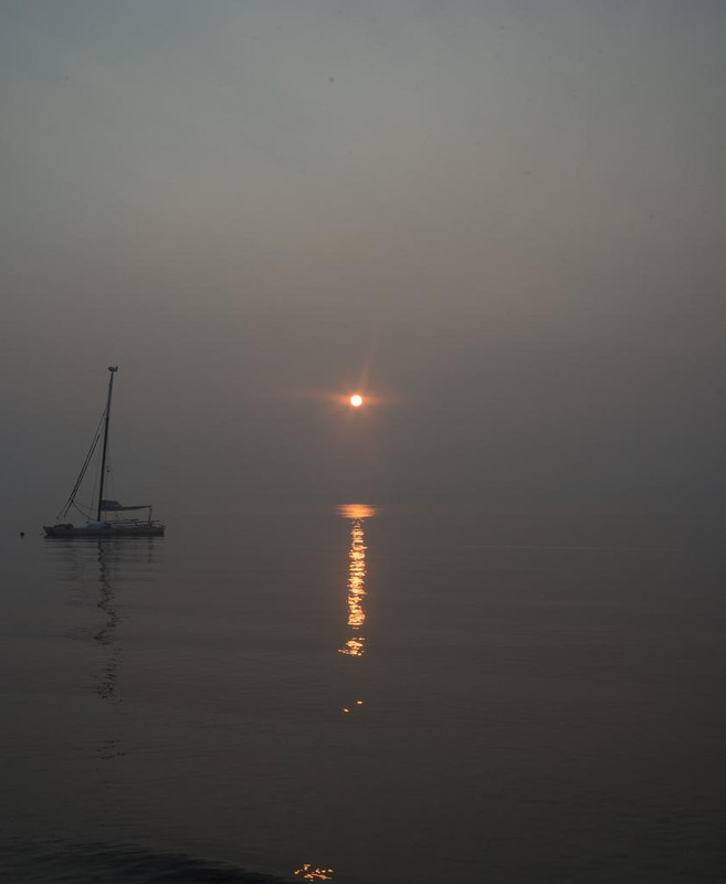
It's been over a week since this province was almost entirely blanketed with smoke (see the photo below, I posted a couple of days in on the "mundane" thread.) Today is the worst yet locally, and we're a few hundred miles from a fire of any size. People who have to work outside are wearing masks. Minor ongoing physical effects are becoming more noticeable, sore eyes and throat, sneezing, etc. It's been suggested I skip gym on Friday if things don't improve. Fortunately that may happen, offshore winds are expected to pick-up tonight and rain is a possibility over the weekend. On the plus side the fire and smoke has replaced Donald Trump as the go-to topic of coffee shop conversation.
At 500 AM HST (1500 UTC), the center of Hurricane Lane was located
near latitude 16.9 North, longitude 157.4 West. Lane is moving
toward the northwest near 7 mph (11 km/h). A turn toward the
north-northwest and little change in forward speed is expected
today. A turn toward the north is anticipated tonight and Friday, as
Lane's forward motion slows. A turn toward the west is expected on
Saturday and Sunday, with an increase in forward speed. On the
forecast track, the center of Lane will move very close to or over
the portions of the main Hawaiian islands later today through
Friday.
WIND: Tropical storm conditions are expected on portions of the Big
Island beginning later this morning, with hurricane conditions
expected in some areas by tonight. Tropical storm conditions are
expected to begin over portions of Maui County later today,
with hurricane conditions expected in some areas by Friday.
Tropical storm conditions are expected to begin on Oahu late
tonight, with hurricane conditions expected Friday into Friday
night.
RAINFALL: Rain bands from Hurricane Lane will continue to overspread
the Hawaiian Islands. Excessive rainfall associated with Lane will
impact the Hawaiian Islands into the weekend, leading to significant
and life-threatening flash flooding and landslides. Lane is expected
to produce total rain accumulations of 10 to 20 inches, with
localized amounts in excess of 30 inches over the Hawaiian Islands.
Over 12 inches of rain has already fallen on portions of the Big
Island.
SURF: As Lane is slow-moving, large swells generated by the
hurricane will severely impact the Hawaiian Islands over the next
couple of days. These swells will produce very large and damaging
surf along exposed west and south facing shorelines. A prolonged
period of high surf will likely lead to significant coastal erosion.
STORM SURGE: The combination of a dangerous storm surge and large
breaking waves will raise water levels by as much as 2 to 4 feet
above normal tide levels along south and west facing shores near
the center of Lane. The surge will be accompanied by large and
destructive waves.
Highest winds my area will get are probably 45mph, which is probably going to damage trees but not buildings, but Alabama will have a bigger wind factor than that.
Hurricane Florence looks like it could be very, very unpleasant for whichever parts of the US East Coast it eventually hits - which now looks almost inevitable. It's travelling over very warm water, and there seem to be little windshear to disrupt it, so it's currently predicted to hit somewhere between Savannah and Norfolk as a Cat 4 storm!
All of that area is incredibly low-lying, and there's potential for a massive rainfall event on top of the wind coming in.
I guess AHC in New Bern is our OTFer who's most in the firing line. Here's hoping it gives you a wide berth, but also that you have a good evacuation plan in place, just in case.
Having been on the Outer Banks during a lesser hurricane, I fear for them at this point. I believe that both Carolinas and Virginia have declared States of emergency in anticipation of landfall late in the week.
Yep. State of Emergency. Battening down the hatches. It's not the wind that worries me so much (although Matthew damaged my house) but the rain. We are at the confluence of the Trent (reminder of Nottingham) and the Neuse. It is very low lying and all the little streams and creeks rise very quickly.
Parts of New Bern can flood but Lumberton, Morehead City, Havelock etc. can get pasted. They will take care of Havelock because of MCAS Cherry Point but everywhere else will have to take care of itself.
While NM probably brought you an insane amount of frustration, there has been no state that i've lived that has less of a chance of any meteorological disaster than the land of enchantment. OK, there is the reality of serious long-term drought, but other than that.....
On Thursday, after a week of fairly wet and/or very hot days, the forecast for Saturday was zero percent chance of rain. So I decided to not mow the lawn and let it dry out a bit. When Saturday arrived, not only was it raining, but it rained all day, and hasn�t stopped since. It won�t store until Tuesday. My grass is too long.
While NM probably brought you an insane amount of frustration, there has been no state that i've lived that has less of a chance of any meteorological disaster than the land of enchantment. OK, there is the reality of serious long-term drought, but other than that.....
May be true Cal but, in the Four Corners anyway, you get haboobs, mud rain, snow thunder, days of 112 degree heat and minus Fahrenheit temperatures at night.


Comment