Announcement

Collapse
No announcement yet.

Who likes looking at maps?

Collapse
X
 
  • Filter
  • Time
  • Show
Clear All
new posts

    I've always liked this French one

    Comment


      That rather looks like a giant tentacled creature squatting on Paris.

      Comment


        Your point being?

        Comment


          I was wondering how long it would take someone to tap that in, I was anticipating 3-5 minutes.

          Comment


            https://twitter.com/alexsakalis/status/1264483531696353285?s=20

            Comment


              That's very nice. Though I want to protest against the lack of a Brasov-Cluj-Budapest line, partly because that's the actual line I live on, and partly because I can;t actually see why it's been omitted.

              Comment


                I'm irked by the lack of Sarajevo and Pristina connections. This is a Serbian dream!

                Comment


                  Montenegrins stuck on the buses as well!

                  Comment


                    Including Italy (or Austria if one is being Habsburgisch) in the Balkans is a take

                    Comment


                      I'd be more concerned with Hungary than Istria if containing it in the Balkans was the big issue.

                      Comment


                        The geographic boundaries of the Welsh language in 1750 - reminds me of the similar Irish-language map before the Famine:

                        Comment


                          Comment


                            That Wales map is fascinating to me. It wouldn't take much being stripped off for me to have no idea what it was trying to represent.

                            Comment


                              Odd to see the small village that my mother grew up in on there.

                              Coincidentally I realised in the last 24 hours how out of touch I was with the current local government/county structure in Wales.

                              Comment


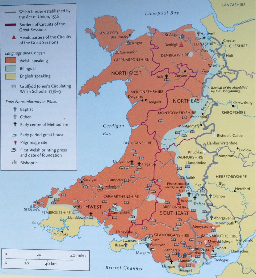
                                If you're not paying too much attention, the Welsh one looks like the bilingual area is a wide river separating the Welsh speaking parts from the English. Which is, I suspect, how a lot would still like it today.

                                Comment


                                  Game hunting map, USSR 1939

                                  Comment


                                    So, so many questions from that one VT. Just a few of those that spring to mind:

                                    Did the huntsman in the NE get his dog to play pat-a-cake with the bear to distract him?
                                    Has the huntsman slightly to the SW of him run out of bullets, and therefore decided to bayonet the bear?
                                    Why is the plane at the top about to crash into an ice floe?
                                    What exactly are the animals in the SSE bit - reindeer wearing white stockings?
                                    Speaking of which, in the top centre that seems to be a diced walrus talking to a skinny Loch Ness monster - what's that about?
                                    That bit in the SW central - are those the spirit rabbits that sang Bright Eyes on Watership Down?

                                    I actually want that map on my wall

                                    Comment


                                      Comment


                                        My pressing question on the Soviet map is how they got the structure in the South Central region to 8th Avenue and 33rd Street about three decades later

                                        Comment


                                          Interesting that the topologist included Somaliland.

                                          Comment


                                            Palestine is wrong on that topology map. It has a border with Egypt too

                                            Comment


                                              Should't the Uk be connected to France via the tunnel and Denmark to Sweden via the bridge?

                                              Comment


                                                I guess they are counting the Gaza strip as an exclave, as per the note in the bottom left.

                                                Comment


                                                  Originally posted by Diable Rouge View Post
                                                  The geographic boundaries of the Welsh language in 1750 - reminds me of the similar Irish-language map before the Famine:

                                                  Noticeable that Monmouthshire is on the English side of the border there

                                                  Comment


                                                    It was until 1969, if my memory serves me well...

                                                    Comment

                                                    Working...
                                                    X